Water
Watersheds
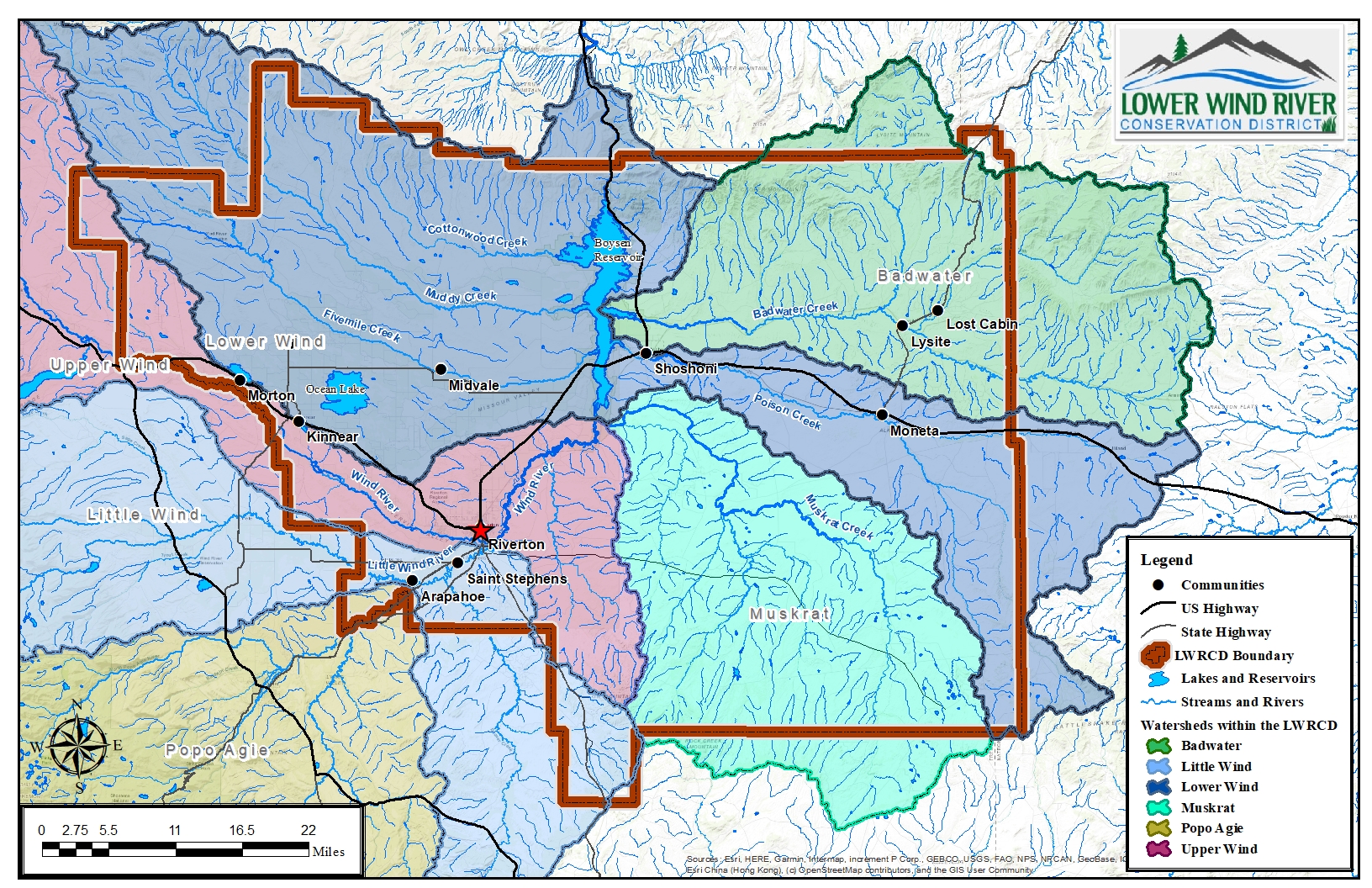
The conservation and protection of surface waters within the Lower Wind River Conservation District is a main goal of the District. With an average annual rainfall of 10 inches, water in our semi-arid region is highly valued. From lakes and reservoirs, small ephemeral and intermittent streams to the Big and Little Wind Rivers and irrigation canals, our District features unique water conveyance and storage systems that support a large part of our economy.
To better understand our water storage and conveyance, as well as water quality and protection, we analyze the makeup of our six main watersheds with the District. What is a watershed? A watershed is an area of land where all the water that falls, such as rain or snow, drains into a common outlet like a river, lake, or ocean. In our region, that outlet is Boysen Reservoir. Why do watersheds matter? They influence water quality and supply, contribute to flood control and ecosystem health, and the activities within our watersheds impact downstream areas.
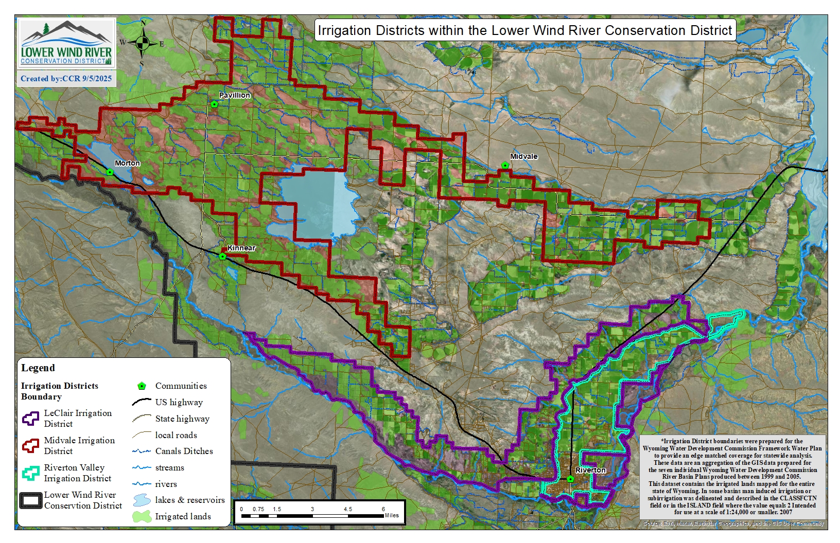
For specific questions and information about water conveyance, and how it’s managed in our area please see the attached map and/or refer to the below contacts:
- State Engineers Office: 307-856-0747
- LeClair Irrigation District: 307-856-4018
- Midvale Irrigation District: 307-856-6359
- Riverton Valley Irrigation District: 307-856-3103
- Bureau of Reclamation, Wyoming Area Office: 307-261-5671
- Riverton Public Works Department: 307- 856-3687
Well Water Testing
We provide three testing options to cater to your specific needs as described below along with pricing options. Test kits are available for pick-up anytime before the testing day at our office. Please test the morning of the water testing day and bring your samples back to our office between 9 a.m. – 12 p.m.
Our 2025 Testing Dates are the 3rd Wednesday’s of the following months:
- April 16, 2025
- May 21, 2025
- October 15, 2025
As per WYDEQ, results should be valid for 3-5 years provided there are no major changes to your water system. We kindly ask that if you have recently had your system tested with no negative results to contact our office if you are considering testing your well again. Please do not hesitate to contact our office if you have any questions or concerns.
For alternate methods of water testing within Fremont County and the surrounding area, please click here!
Please refer to the “Resource Conservation” page of our website and view the Analysis Cost-share document for additional details.
Harmful Cyanobacterial Blooms
In 2024 the LWRCD assisted the Wyoming Department of Environmental Quality (WDEQ) with Harmful Cyanobacteria (HCB) monitoring on Boysen Reservoir. The monitoring consisted of gathering information of what is occurring, including if a visible bloom is present, at various locations around Boysen every two weeks. Algal blooms were present at Boysen from July-October; however not all algae are bad algae! Two primary water samples were collected to determine if there is a presence of Cyanotoxins and Microcystin in the blooms. If the presence of either is above certain thresholds, the information is posted as a bloom or toxin advisory promoting caution, as these can be harmful to livestock, pets and humans if ingested. To follow HCBs advisories check out Harmful Cyanobacterial Blooms (wyohcbs.org). You can sign up to receive updates on HCBs and advisories on their website.
Listed Impaired water sources
There are three waters in the district that are currently considered impaired by the Wyoming Department of Environmental Quality. The district has been conducting water quality monitoring on all three waters through grants from the Wyoming Department of Agriculture.
Muddy Creek—listed as impaired due to E.coli from Boysen Reservoir upstream to the Wind River Indian Reservation boundary
Poison Creek—listed as impaired due to E.coli from Boysen Reservoir upstream for two miles
Ocean Lake—currently on the WDEQ Category 4 waters which means that the lake is impaired or threatened for a warm water fishery due to sediment and a Total Maximum Daily Load (TMDL) was written.
Emergency Watershed Protection
The district has sponsored six Emergency Water Protection (EWP) Projects through the Natural Resource Conservation Service. Three were designed to help stabilize the bank of the Big Wind River when high water threatened the lives and homes of five families, when the Little Wind River threatened an irrigation canal, and when the Big Wind River threatened a headgate, irrigation ditch, livelihoods and property.
Education
We provide educational programs to youth and adults. We have materials from many sources including Wyoming Ag in the Classroom. Most of these activities are hands-on and cover a variety of topics including...
Tree & Shrub Sales
This program encourages landowners to plant effective wind barriers, to protect buildings, cropland and feedlots as well as for erosion control, reforestation and other conservation practices. We encourage people to plan their windbreaks before planting. Technical assistance is…
Plans & Policy
The Land Use and Natural Resource Management Plan provides information about the goals and objectives of the Board of Supervisors. To view the plan, click the following link: Long Range Plan 2021-2025 The district was a cooperating agency in the…


